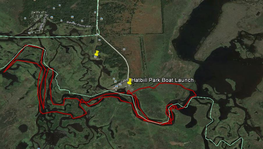
I decided to try something different today and launch from Hatbill Park in search of shad. There have been reports of fish being caught up by SR 50 and everywhere in between already, so I decided to break the monotony of fishing the same areas near CS Lee, particularly since it is busier each day. Hatbill Park is a bit off of the beaten path and requires a 5 mile journey down a worn out dirt road to get to. The concrete boat launch is VERY steep as well, so this matched with the long dirt road keeps the power boat traffic to a minimum. Air boats, well that was another story and if you are a kayaker like I am, you want to be real aware that the airboats are not very accustomed to seeing you out there, especially on the inside of a turn. Some of the area is very narrow and the grass very high, so you need to be aware that an airboat may not see you until its just about too late. Take the outside of turns to be safe, and a flag would be even better.
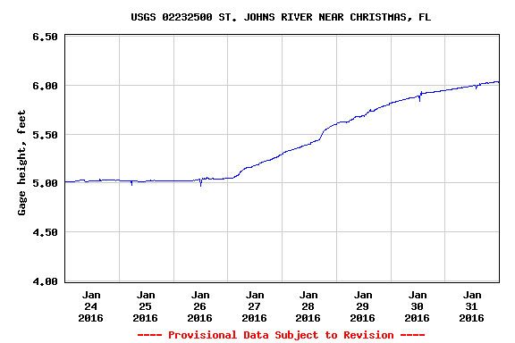
My intention when I set out was to bring my copy of Luc Desjarlais’ book Wade Fly Fishing The Upper St. Johns River Basin (Florida) for American Shad as a guide, as I have not spent as much time on this area of the river as I have others. Luc quite literally circles the fishy areas of the map, so it is an amazing resource to the fly fisherman in pursuit of shad. Of course in my haste, I left the book at home and had to depend on a mixture of dead reckoning and google maps to find areas to fish. The water on the river in this area was up nearly a foot from the rains we had during the week, and a lot of the area was under water. The water flow was whipping and I managed to find a few areas where I was comfortable wading, and a few more that were underwater, but I knew would be dry once the water receded. Upon inspecting my route on google earth and comparing it to places Luc recommends in his book, I was surprised to see that I naturally chose quite a few of the same areas in the book. My natural inclination was to seek the current of the main channel, narrow or deep turns, and areas where the channel splits and reconvenes causing increases or turbulence in flow.
I made it to Junction One detailed in Lucs book and spent a fair amount of time swinging flies there without much luck. I also made it to the area detailed near Ruth’s Lake and did not hook up there either. I fished several areas in between and got nothing but a skunk. I would imagine that there are indeed shad in this area of the river already, but the high water probably allowed them to disperse rather than concentrate in the main area of the channel.
A couple of other things to consider if you are thinking about venturing out to Hatbill this week. First, the high water and flow has pushed TONS of water hyacinth in to free flow on the river. Of course the small amount of wind helped push it all to one side of the river today, the one that had shallow or dry areas free of high grass or in other words, the side that I was standing on. 🙂 This quite frankly was not very fun to fish. Second, there are a lot of alligators in the area… BIG ONES! There were several areas that I wanted to wade where I was greeted by toothy friends. Being alone, I decided to play it safe and yield. The water temps are still low, but the air temperature has increased making the gators much more active. There were two areas of the river where I was wading and heard alligators bellow. If you have never heard this in the wild, let me tell you… it is disconcerting to say the least to hear an alligator but not be able to see it. I got my butt back in my boat like a flash and went on my merry way.
Although the fishing was slow, I enjoyed exploring different places along the river to try next time. The Hatbill area is a nice change of scenery and I look forward to fishing there again soon. That said, I will wait for the water to recede and leave me some dry areas to fish from, and would prefer to fish the area with temperatures in the 50’s rather than the mid to high 70’s.
Water levels of around 2.5-3.0 feet are considered optimal if kayaking and wading. As you can see, the water level was much higher leaving a lot of the area under water.