One of the most valuable things to know before you head out to shad fish is whether the water conditions are suitable for catching fish. Shad like some pretty specific water conditions for spawning, and if the water conditions are not great, catching fish can be difficult if you do not change tactics. Here in Florida, the St Johns River ebbs and flows with the amount of rain received throughout the year. This means year to year when shad season is upon us, the water conditions can vary greatly, and that affects the behavior of the fish and fishermen alike. There are years where there is so much rain down south in the fall, that the river remains outside its banks long after the fish have arrived, and years where it seems there is barely a trickle.
Optimal water conditions for shad fishing on the St Johns River are when the river is within its banks, there is still a decent flow, and the temperature is below seventy degrees. Luckily for us, we can get up to date water conditions without ever putting a boat in the water. The United States Geological Survey monitors water resources through a network of water gauges on rivers, streams, and lakes all over the country, and data from those meters is available online.
There are four water gauges that I check regularly based on where I am fishing:
- USGS 02234435 LAKE JESUP OUTLET NEAR SANFORD, FL– This gauge will help you with water conditions near the Lemon Bluff (or Shad Alley) area of the river
- USGS 02234000 ST. JOHNS RIVER ABOVE LAKE HARNEY NEAR GENEVA, FL– This gauge will help you with water conditions on the upper St Johns near the
Econlockhatchee River and Puzzle Lake area - USGS 02232500 ST. JOHNS RIVER NEAR CHRISTMAS, FL– This gauge will help you with water conditions on the upper St Johns near SR50
- USGS 02232400 ST. JOHNS RIVER NEAR COCOA, FL– This gauge will help you with water conditions on the upper St Johns near SR520
A good baseline for me is when USGS 02234000 says that the water level is at or below 4.5 feet, the discharge is around 1800, and the temp is below seventy degrees (at least at night.) If the conditions are near those, I know it is time to start fishing. There are obviously years where those conditions are not reached until well in to the shad run though, and during those years, you must adapt to catch fish. Take the 2014/2015 shad run for instance, and let’s look at some historical data from USGS 02234000 during the 2014/2015 run…
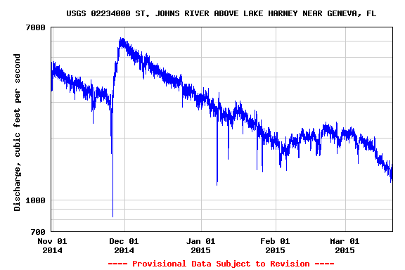
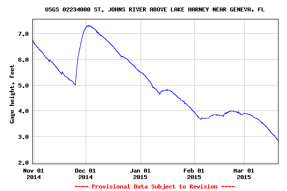
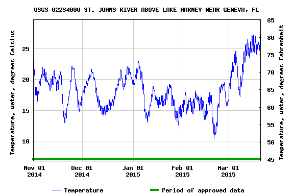
The water was at near record highs and the discharge was unbelievable for the St Johns River when the fish arrived in 2014. While I caught some fish in January, it took a switch rod and T8 or T11 sink tips to get the fly down. My season did not really heat up until February 7th, when I broke double digits and landed 16 in 4 hours. Even through February, the discharge was relatively high and still required sink tips to have productive days. By the time the conditions really hit my baseline, the fish were well upstream and reports of catches near SR 520 kept coming in through April.
So, use the USGS resources to help you make decisions about where and when to fish, but don’t let specific data cripple you. If conditions are not perfect, that does not mean that you won’t catch fish, you just may need to adapt your tactics. There is still much to be said about going out, exploring, and trying new things. After all, isn’t that what fishing is really all about anyway?
For those outside of Florida, you can easily find water gauges near you by visiting the USGS Mapper.
There is also now a mobile friendly version of the site.